
How to Lie with Maps
Lying with statistics is a common practice; when it comes to Israel, lying with maps is just as common.

The map presented above was published by Al Jazeera this week and purports to show that “From 1947 to 1950, during the Nakba or ‘catastrophe’, Zionist military forces expelled at least 750,000 Palestinians and captured 78% of historic Palestine.” The map is not new, and is consistently used by anti-Israel publications, media outlets, and pundits to “explain” how the Palestinians have been historically oppressed by the foundation and continued existence of the state of Israel. The big problem? Almost none of what the graphic depicts is true, a good deal of it is deliberately misleading, and it leaves out crucial context that undermines the point it is trying to make. Here’s an object lesson in not taking everything you see online at face value.
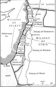
Let’s start with the first map in this graphic, labeled “1917”, which supposedly depicts the area of “Palestine” before the British Mandate which came into being after the First World War. At the time of this map, the region was nominally controlled by the Ottoman Empire, although that Empire had been crumbling for decades and was only a year out from total defeat and dismemberment by the Entente Powers that won World War I. The first important thing to notice is that the region is referred to in the map as “Historic Palestine”, which is – ironically – a completely ahistorical construction. As the map below shows*, this region was administered by the Ottomans in a piecemeal manner, largely under the auspices of regional governors in Damascus (Wilayet of Syria) and Beirut (Wilayet of Beirut); there was no existence in modern-day Israel of any sort of independent state or polity during the time of the Ottomans, which ran from the 17th century all the way through the 20th century. The term “Palestine” itself was a Roman replacement name for the territories known as Judea and Samaria, one deliberately meant to remove the Jewish connection to the land after the crushing of the Judean Revolt and the destruction of the Second Temple by the Romans in 70 AD. There was never an independent state either called “Palestine” or in the territory of modern Israel; it was a battleground of empires for millennia, with Romans, Byzantines, Persians, Umayyads, Crusaders, and Ottomans all controlling it at one time or another.
Besides the clear lie that I just mentioned, the 1917 map from Al Jazeera has other significant problems. First, it labels the small number of blue areas as being under “Jewish control”, while the entire rest of the territory is green, which is labeled “Palestinian”. This is misleading and wrong in multiple ways. The most obvious is that the vast majority of the green-colored territory was (and often still is) entirely uninhabited; the non-Jewish denizens of this region were largely Bedouin Arabs who were unsettled nomads and did not, in any modern conception of the term, own the land that Al Jazeera allots to them. Not only did they not own the land, the vast majority of it was uninhabited desert with few significant cities, mainly Jaffa, Jerusalem, Haifa, and Gaza. As the 1917 map correctly shows, these areas did have Jewish populations that were well-established in the land. That in and of itself is significant, as the Ottoman Empire had banned Jews from owning land or migrating to modern-day Israel in 1881. The areas thus labeled as “Jewish control” were likely well-established communities of indigenous Jews, not European migrants as is often claimed. The last issue with the 1917 map is that it creates, out of whole cloth, a group called the “Palestinians” and grants them control over the whole region. That is not only false because of the aforementioned reasons, but also because the idea of Arab nationalism and joint peoplehood was itself an outgrowth of World War I. Prior to the war, the Arabs who lived and migrated through the region saw themselves as members of their distinct tribe, not as Arabs or Palestinians; oftentimes the internecine conflict between Arab tribes was severe and this division was so pronounced that it hampered the ability of the tribes to evict the imperialist Ottomans from their midst. One of the main reasons why the Ottomans lost the area during the Great War was that Entente agents – including one T.E. Lawrence – deliberately fomented nationalist sentiment and began the process of uniting the disparate tribes into one Arab people. Based on that reality, it is absurd to label any of the region as “Palestinian” when that was a cultural construct not evidenced at the time.
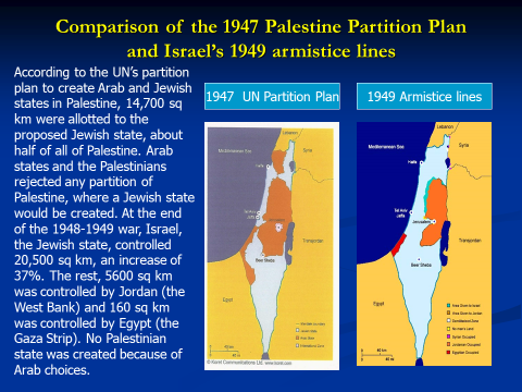
The second map, labeled “1948”, purports to show that “Zionist military forces expelled at least 750,000 Palestinians and captured 78 percent of historic Palestine”. Besides the issues with the term “historic Palestine” laid out above, there are several other problems with this map, including the removal of key context. If you know something about the history of this region, you’ll know that this particular map has been carefully selected; it reflects the outcome of the 1948 First Arab-Israeli War, without explaining the preceding events. The map included below shows one of those preceding events: the proposed United Nations partition plan from 1947, which was meant to give both Jews and Arabs national states in the region. As you can see in that map, which Israel gladly accepted, there would be significant territories which would be reserved to a future Palestinian state – far more land than the Al Jazeera 1948 map depicts. The reason why there is no modern Palestine based on these 1947 borders is the war which the Arabs launched against the nascent Israel after completely rejecting the UN plan; this was intended as a war of elimination, and as such the Arab forces had their co-religionist Palestinians evacuate the areas the armies intended to depopulate of Jews. Those 750,000 Palestinians who fled what is now Israel left largely due to the promise of the Arab armies to make these regions entirely Judenrein or Jew-free; they fled to the regions controlled by other states, including Jordan, Lebanon, Syria, and Egypt, where – in most cases – they still remain in the same refugee camps to be used as political pawns for the Arab nations. This was unfortunately a common result of the decolonial process, and can also be seen in the massive population movements in 1947 upon the partition of India and Pakistan. After the war which was started – and lost – by Israel’s Arab neighbors, the state of Israel became a permanent fixture on the world map. The 1948 Al Jazeera map shows this, but claims that it meant Israeli “capture” of most of “historic Palestine”. Israel, in fact, only took over some of the areas allotted to Palestine based on the 1947 UN Plan, leaving the rest to be occupied not by a Palestinian nation, but by Egypt (in Gaza) and Jordan (in the West Bank). The Israeli gain was not, as Al Jazeera claims, 78 percent of Palestinian territory, but instead an increase of 37 percent over what was initially allotted to a Jewish homeland by the UN. At this point in time, there was no nation of “Palestine” and one had never existed before this point.

The third map that is included on Al Jazeera’s graphic is labeled “1967”, and claims to show the aftermath of another Israeli “conquest” and the further “expulsion” of 300,000 Arabs from their homes. One of the misleading things about this map is how it assigns blame for the 1967 Six Day War to the Israelis, when it is widely agreed by historians that the conflict was a defensive war that came after large-scale state-sponsored terrorism by the Arabs and preceded what was very likely to be a second war of extermination against the Jews of Israel. The war was not a war of Israel versus the Palestinians, but Israel against a number of Arab powers on its borders; the land occupied by Israel after the war included significant territories which had been previously occupied by Jordan, Lebanon, Egypt, and Syria. Since the end of that brief conflict, Israel has ceded more than 90 percent of that land back to the other belligerent states, including unilaterally withdrawing from southern Lebanon and ceding the Sinai to Egypt and some of the West Bank to Jordan as part of peace agreements with those countries. Israeli occupation of the Gaza Strip and West Bank continued after the war, as a means of providing security from future attacks emanating from the border regions. Israel did not expel all Palestinians from these newly-occupied territories, and has allowed them to remain in both areas ever since. This is the exact opposite of how Jews in the rest of the Middle East were treated after the 1948 war, when those millennia-old Jewish communities were forcibly exiled and found refuge in Israel, where they now make up a significant percentage of the population. There are also several million Arab citizens of Israel, where they are allowed to vote and make up a key constituency in the current government; Arabs have no such voting rights in the vast majority of other Middle Eastern countries, which are either run by hereditary monarchies or brutal dictatorships.
The fourth map in the Al Jazeera graphic, labeled “1995”, shows the agreed-upon outcome of the 1993 Oslo Accords, which began the modern Israel-Palestinian peace process after decades of total rejectionism from the Palestinian side. That rejectionism was in reference to the antisemitic and anti-Zionist idea that there should be no Jewish state in the land of Israel and the entire land of “historic Palestine” should be controlled by Arabs. The Oslo Accords were a breakthrough in Israel-Palestinian negotiations, as it marked the first time that both sides agreed to a two-state solution and a ceasing of the terrorist violence so commonly used by the Palestine Liberation Organization (PLO) under Yasser Arafat. Unfortunately, old habits die hard, and the use of terrorism and the idea of rejectionism quickly came back into vogue after 1995; in the following years, terror attacks increased in prevalence and tensions rose. One attempt to ameliorate those tensions was put forward by then-Israeli Prime Minister Ehud Barak in 2000 at the Camp David Summit hosted by then-US President Bill Clinton. The Barak offer was for a two-state solution, and included many concessions from the Israeli side in exchange for an end to hostilities, including ceding the holiest place in Judaism – the Temple Mount – to a newly-created Palestine. Arafat rejected this entirely, instead starting a terror campaign against Israeli citizens that killed more than 1,000 civilians. The map presented by Al Jazeera completely ignores the fact that only a few years after the Oslo Accords, the Palestinians could have had an independent state largely on the boundaries they were asking for and outright rejected it in favor of their goal of utterly destroying the state of Israel.
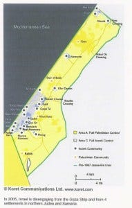
Al Jazeera’s final map, from the proposed 2020 US peace plan for the region, shows that this plan would leave Palestinians “only 15 percent of historic Palestine”. Again, this map leaves out crucial context; this time it ignores the multiple peace offers in between 1995 and 2020, as well as the unilateral Israeli withdrawal from Gaza and the events which followed it. As stated above, Israel offered peace terms to the Palestinians several times between 1995 and 2020, all of which would have granted a new Palestinian state more territory than the Trump plan would; each time those proposals were rejected. Besides that, the map leaves out the fact that Israel unilaterally withdrew from the entirety of Gaza, forcing out thousands of its own citizens from their homes and leaving millions of dollars of critical infrastructure intact for the Palestinians who remained. The map above shows the extent of those Jewish settlements before the disengagement; it is quite clear that this was a significant move from the Israeli side in search of peace, as it resulted in the removal of many settlements and was not all that popular politically. As a result of this good faith move, the settlements and infrastructure were destroyed and, only a year later, Hamas – an actual, active terrorist group – assumed control of the territory. Hamas has ruled Gaza ever since, repressing its people and firing indiscriminate rocket barrages at Israeli cities on a near-constant basis, including earlier this year. Given the results of the Gaza disengagement, one could understand if Israel was not interested in peace talks, but they still have not closed off the possibility of a two-state solution. Palestinian leadership and terror groups, on the other hand, have all but foreclosed that potential through their support for violence and demands for a free Palestine “from the river to the sea” – one which would eliminate Israel and remove the Jews from their ancestral homeland.
Maps are an incredibly useful tool for explaining geopolitics to the average reader. They can incorporate a massive amount of important information in a format that is easily understandable and often quite engaging. They can also be used to lie, obfuscate, and mislead; the Al Jazeera graphic above is a perfect example of this malign tendency. In this case, the map is not wrong unintentionally; it is deliberately meant to mislead by removing key context, misrepresenting historical fact, and selectively choosing what to show – and what not to. Unfortunately, this particular map has been reproduced and promulgated consistently over the past few years (with alterations here and there) to attack Israel, demonize its history, and claim that Palestinians are simply permanent victims in a classic oppressor-oppressed dynamic. That does a disservice not only to Israel, but to the history of the region and the complexity of the Israel-Palestinian issue. I can only hope that my contribution to this discourse can help explain some of those complexities and debunk such a blatant attempt at misinformation. Remember: don’t believe everything you see on a map; always question the source and investigate for yourself. If something looks to good to be true, especially on the Internet, it probably is.
* The maps included in this piece, besides the Al Jazeera graphic, have been obtained from this site, which is a great resource for maps of Israeli and modern Middle Eastern history.